The Gangkar Puensum Trek offers an unforgettable wilderness adventure. It takes you to the base of Gangkar Puensum, the world’s highest unclimbed peak. This journey blends rugged exploration with awe-inspiring natural beauty. As you trek, you’ll navigate rugged Himalayan landscapes. You’ll explore pristine valleys and hidden glacial lakes. Jaw-dropping vistas of snowcapped peaks will leave you amazed. Along the way, you’ll traverse untouched cultures. Ancient trails will immerse you in a world few have witnessed. More than a physical test, this trek connects you to nature’s raw power. Crisp mountain air, roaring rivers, and silent forests become your companions.
The Gangkar Puensum Trek is for seasoned adventurers in peak condition. It rewards every grueling step with raw beauty and lifelong memories. Whether you love high-altitude passes or serene wilderness, this trek promises profound respect for Earth’s grandeur. Ultimately, it’s an adventure etched forever in your soul.
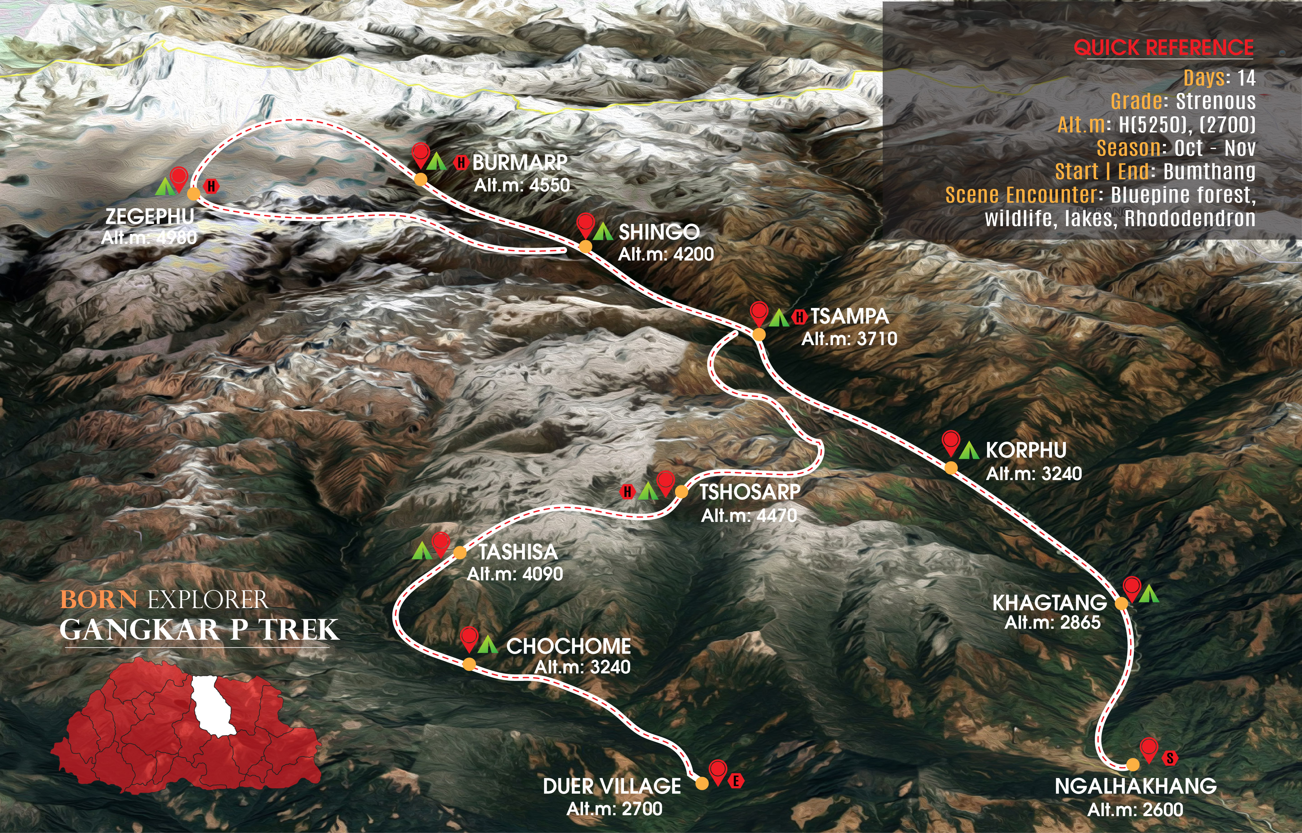
DAY 01: PARO – PUNAKHA (1350 m) | 126 km | 03 hr
Upon arrival at Paro airport, you will meet your guide and drive to Punakha. The journey covers 125 km, and with the improved highway, it can be accomplished in around 3 hours. Punakha is deeply connected to some of the most significant events in Bhutanese history and served as the capital of Bhutan until 1955. Additionally, it is the place where the Bhutanese people elected their first king, Gongsar Ugyen Wangchuk, who became the king of Bhutan in 1907. Typically, there will be an opportunity to visit the remarkable Punakha Dzong, situated at the confluence of two rivers. [Hotel, LD].
DAY 02: PUNAKHA – JAKAR (BUMTHANG, 2600 m) | 66 km | 02 hr
In the morning, you will visit the Trongsa Royal Heritage Museum. This museum is located on the hillside overlooking the main dzong and houses an impressive collection of artifacts. After leaving Trongsa, you will drive to Bumthang, entering a region where the landscape is reminiscent of parts of Switzerland. This is a short drive, and there will be time to explore some of the monasteries in the main valley during the afternoon. [Hotel, BLD].
DAY 03: JAKAR - THANGBI – KHAKTHANG (2865 m) | 05-06 hr
In the morning, you will be driven to Tangbi, about a 30-minute ride. After meeting your trekking team, you’ll start walking along a rough dirt road. The trail follows the river’s left bank through farmland and woodland. In 1-2 hours, you’ll see Drapham Dzong’s ruins on a hill across the river. Passing a small village, you’ll take a track down to a bridge, cross the river, and walk 15-20 minutes to Nga Lhakhang temple. After visiting, you’ll return to the bridge and continue up the valley, passing a school and an old temple. The track then enters a small village with a hillside temple. The valley bends sharply right, and you’ll leave the dirt road, following a trail along the valley floor. As the valley narrows, you’ll reach your first campsite near a small chorten. [Camp, BLD].
DAY 04: KHAKTHANG – KORPHU (3240 m) | 05-06 hr
After leaving camp, you will pass a small Royal Bhutan Army encampment and enter the forest. The trail gradually ascends the Chamkhar Chuu valley on a rocky path through dense fir, rhododendron, and pine forests. The fast-flowing river will be on your right for most of the day. You will pass a water-driven prayer wheel and a traditional wooden cantilever bridge without crossing. As the valley narrows, cliffs rise on either side. After 4-5 hours, you’ll reach a newly built guesthouse near a tributary. Shortly after, you’ll see a steel box-girder bridge but will continue on the left bank. After another half-hour, you’ll reach a steel suspension bridge, crossing to the right bank. A short 15-minute walk brings you to your riverside campsite. [Camp, BLD].
DAY 05: KORPHU – TSAMPA (3710 m) | 06-07 hr
You will ascend the valley with the river on your left, weaving through dense forest. The rocky trail can be muddy and slippery after rain. As the gorge narrows, cliffs rise on the left. Eventually, the valley opens, and the forest thins, revealing a large junction. The right fork (Mela Chhu) leads northeast to the Mȍnlakarchung Pass, once crossed to Tibet in 1922. The left fork follows the Chamkhar Chuu toward the high mountains. You will bear slightly right, passing a small Royal Bhutan Army camp and crossing a bridge over the Mela Chhu. Then, turning left, you will walk across a meadow to your campsite below a newly rebuilt temple overlooking the river confluence. [Camp, BLD].
DAY 06: TSAMPA – SHINGO (4200 m) | 05 hr, or perhaps a higher campsite
This is a beautiful day’s trek as you gradually ascend the valley with the river on your left. The trail passes through forest, increasingly dominated by rhododendrons. Some sections are rough and boulder-strewn. Along the way, you will pass several summer settlements, each with 4-6 stone huts used by yak herders. Depending on the season, some may be occupied, and you might be invited in for yak-butter tea and fresh cheese. Approaching Shingo, the forest gives way to open terrain, with a large cliff on your right. Just before Shingo, you’ll see a bridge but should stay on the right bank. If the group is acclimatizing well, you may camp slightly higher in the valley. [Camp, BLD].
DAY 07: SHINGO – MELUNGHI GANG BASECAMP (4550 m) | 05-06 hr
You will continue up the right side of the valley, enjoying ever-improving views. Now clear of the forest, the walk along the valley floor is easy and scenic. You’ll pass Serchy, where prayer flags adorn a small knoll above a summer settlement. As you near Bamurpa (4,490 m), the valley bends right, revealing a breathtaking view of Melunghi Gang (6,902 m), weather permitting. Bamurpa offers a good campsite, but you’ll continue toward the glacier. Staying on the right-hand edge of the valley floor, you’ll follow a faint trail for another 1-2 hours, reaching the terminal moraine. Just below it are derelict yak herders’ huts at Bibsam (Buurtsam), where you will camp for two nights. [Camp, BLD].
DAY 08: MELUNGHI GANG EXPLORATION
This area offers spectacular exploration, and your guide will outline the best options. One option is ascending a ridge northeast of the glacier, leading to a viewpoint at 5,300 m. The steep but manageable climb rewards you with breathtaking views of the glacier, Melunghi Gang, and Gangkar Puensum. Below, a hidden valley features stunning blue lakes surrounded by snow-capped peaks.
Another option is hiking toward the valley head by climbing onto a high shelf above the glacier. From here, you’ll work your way into a basin at the foot of Melunghi Gang’s southeastern ridge. This basin holds another set of beautiful lakes with close-up views of Melunghi Gang and Gangkar Puensum. [Camp, BLD].
DAY 09: MELUNGHI GANG BASECAMP – ZHIGEYPHU (4980 m) | 04-06 hr
oday begins with an easy descent to Bamurpa, where you will wade across the river to the right side of the valley. Continuing down, you’ll reach a yak herder’s hut at the base of the 500 m climb to Zhigeyphu valley. Midway, you’ll pass a cluster of huts at 4,725 m before ascending to a cairn and prayer flags at 4,990 m, marking the valley’s entrance. Shortly after, you’ll arrive at another yak herder’s settlement, your campsite for the next two nights. While Gangkar Puensum’s summit is just visible from camp, a short walk to a nearby rise offers a spectacular view of this majestic peak. [Camp, BLD].
DAY 10: ZHIGEYPHU EXPLORATION
This area offers more spectacular exploration, with several options for making the most of your time. One option is ascending the gentle ridge north of camp to reach a 5,425 m viewpoint. From here, you’ll have breathtaking views of the valley, with numerous colorful lakes and the towering peak of Gangkar Puensum. Surrounding you are jagged peaks up to 6,000 m.
Another option is hiking through the lakes toward the valley head, where you can ascend one of several summits or cols explored on previous trips. This route offers close-up views of Gangkar Puensum’s stunning south face and the immense glaciers to the south and west. [Camp, BLD].
DAY 11: ZHIGEYPHU – TSAMPA (3710 m) | 06-08 hr
Today, you’ll retrace your route down the valley, returning to the campsite near the temple at Tsampa. Leaving Zhigeyphu, you’ll descend to the main valley near Bamurpa but stay on the right bank of the river. After a couple of hours, you’ll reach Shingo, where you camped earlier. Below here, the trail splits. Take the left-hand trail near the river, avoiding the right-hand branch that ascends to yak herder huts. The trail winds around the shoulder, leading to a small wooden bridge to cross to the left bank. From here, you’ll rejoin the earlier trail and continue descending through forest and clearings. After another couple of hours, you’ll return to the Tsampa campsite. [Camp, BLD].
DAY 12: TSAMPA – TSHOSARP (4470 m) | 05-06 hr
Leaving camp, you’ll cross a small bridge over the river and begin a steep ascent through the forest. The trail leads to a meadow with a yak herder’s hut before continuing up through rocky crags and cliffs. The climb soon brings you to a grassy shoulder with panoramic views of the Chamkhar Chhu valley and the Mela Chhu valley, toward Chura Kang and peaks on the Tibetan border. The ascent becomes more gradual as you rise above the treeline, offering great views of the snow-covered peaks east of Melunghi Gang. After crossing a small col, you’ll enter a V-shaped valley leading to Tshosarp, with a dramatic rocky peak ahead. Another hour’s walk brings you to the campsite beside the small lake of Tshosarp. [Camp, BLD].
DAY 13: TSHOSARP EXPLORATION
Today is an opportunity to hike up to a viewpoint high above Tsampa, which provides a fantastic panoramic view of the snow-covered mountains to the north, including Gangkar Puensum, Kula Kangri (over the border in Tibet), and Chura Kang (further to the east). This day-hike begins with a climb up the grassy slope behind the camp, passing a big rocky outcrop covered in prayer flags to the left, before skirting around a lake and then climbing up onto a ridge to gain the views from the top. [Camp, BLD].
DAY 14: TSHOSARP – TASHISA (4090 m) | 05-06 hr
Leaving camp, you’ll follow the trail around the right side of the lake and begin a gradual ascent towards the pass. As the trail steepens near the Thole La (4,760 m), you’ll reach the pass within a couple of hours. From there, enjoy views of the Tibetan border’s high peaks and a deep valley with granite rock faces. To the right is a hanging valley with a stream flowing down. The descent to the valley floor is steep at first, becoming more gradual. The trail crosses boggy areas and involves some stone hopping. Stick to the left side of the stream, even though horsemen may cross it several times. As the ground improves, you’ll reach Labrong, cross a small bridge to the right bank, and continue for 15 more minutes to your campsite. If you have energy, there are opportunities for an afternoon walk. [Camp, BLD].
DAY 15: TASHISA – CHOCHOMEY (3240 m) | 05-06 hr
Leaving camp, you will descend gradually through rhododendron forest until (after about an hour) you reach a junction. Here, you will cross the stream you have been following by a small bridge and join the main trail from Lunana to Bumthang. The trail now follows the left bank of the river, and you will again walk through a rich and diverse forest. Eventually, you will come to a small bridge, and after crossing to the other side of the river, you will climb up through the forest for 45-60 minutes to reach your campsite in a clearing of the forest at Chochomey. [Camp, BLD].
DAY 16: CHOCHOMEY – DUR (ca. 2700 m) – JAKAR | 03-04 hr
Today, you will complete the trek by following the trail down through the forest to Dur. Once again, you will descend through beautiful and untouched forests, including one or two sections next to the river. The end comes suddenly – one moment you are in virgin forest, and then suddenly you are on a rough dirt road in the forest. A short walk along this track (including a final uphill section!) will bring you to the small farming community of Dur, the home of your horsemen. Here, you will sadly say goodbye to your hardworking staff and horsemen and then depart for the short road journey back to Jakar (Bumthang). [Hotel, BLD].
DAY 17: JAKAR (BUMTHANG) – PARO | 300 km | 08 hr
An early check-out is required for the long drive back to Paro. We will make a stop for lunch, and there will undoubtedly be photo opportunities that will occasion additional stops and breaks along the journey. Our aim is to reach the hotel in Paro by mid/late afternoon. Note: An alternative option is to stay the night in Punakha and complete the drive to Paro the following day. [Hotel, BLD].
DAY 18: HIKE TO THE FAMOUS TIGER’S NEST
We suggest making an early start since the hike up to Tiger’s Nest is quite an uphill task and takes around 3-4 hours. Taktshang Goemba is notably one of the most popular Buddhist temples in the entire Himalayas, dating back to the 8th century. It clings to a vertical cliff drop of nearly 3100 m above sea level. History reveals that in the second half of the 8th century, Guru Padmasambhava visited the site and underwent three months of meditation. Your guide will provide detailed information once you arrive. After returning from Taktshang Goemba, you will make a short visit to the historical Kyichu Lhakhang.
DAY 19: Depart Bhutan
THE QUOTED BHUTAN TOUR COST INCLUDES THE FOLLOWING
Your Bhutan tour package comprehensively covers the following services and amenities:
Firstly, the rate includes all three meals, featuring both local and continental healthy cuisine.
Additionally, accommodation in three-star hotels on a twin/double sharing basis is provided.
Moreover, you’ll enjoy air-conditioned, tourist-standard transportation throughout your journey.
Furthermore, a licensed English-speaking guide will accompany you on all sightseeing tours.
The package also provides extensive, flexible itineraries tailored to your preferences.
Importantly, the Bhutan Government royalty fees of $100 per person per night are included.
Additionally, all entry fees, museum charges, and historical attraction costs are covered.
All applicable taxes, including BST (10%) and service charge (10%), are part of the rate.
Lastly, the one-time visa fee ($40) and airport arrival and departure transfers in Bhutan are included.
INCLUSIVE TREK AND CAMPING
For trekking and camping adventures, the following are included:
Your package features dining tents, toilet tents, twin-sharing sleeping tents, mattresses, and essential camping equipment.
A basic first aid kit is also provided for safety during treks.
Additionally, local drinks, including wine, are included to enhance your experience.
Moreover, a dedicated support team (guide, cook, assistants) ensures a smooth trek.
Furthermore, ponies and yaks (with handlers) are available for transport during the trek.
COMPLEMENTARY SERVICES
To further enrich your journey, the following complimentary services are offered:
Upon arrival, refreshments will be provided to welcome you.
Each day, you’ll receive a bottle of mineral water.
On departure, a small farewell gift will be presented as a token of appreciation.
For groups exceeding seven members, a cultural program and a traditional farewell dinner at a local farmhouse are included.
THE QUOTED BHUTAN TOUR COST DOES NOT INCLUDE THE FOLLOWING
Please note that the following are not covered:
Firstly, incoming/outgoing Bhutan airfares and airport taxes are excluded.
Additionally, drinks (alcoholic/non-alcoholic) beyond specified inclusions are not covered.
Guides speaking languages other than English incur extra charges.
Expenses of a personal nature, such as tipping, laundry, phone calls, or medical costs, are your responsibility.
Moreover, extra costs due to unforeseen events (e.g., natural disruptions) are not included.
Services outside Bhutan or bank transfer fees ($45) are excluded.
Lastly, tipping for guides, drivers, etc., is at your discretion.
Spanning elevations from 2,500 m to 5,200 m, the Gangkar Puensum trek challenges adventurers with rugged terrain. Trekkers traverse dense forests, alpine meadows, and rocky ridges, all while marveling at Bhutan’s towering Gangkar Puensum. Additionally, glistening streams, rivers, and remote villages further enrich this unforgettable journey.
Well-marked with cairns, painted stones, and prayer flags at significant points, the trail ensures a smooth journey. Moreover, clear directional markers guide trekkers at critical junctures, especially near steep ascents, ultimately helping adventurers navigate challenging terrain and stay on track through Bhutan’s rugged mountains.
Gangkar Puensum Trek offers fresh streams and rivers, water purification remains essential. Despite no designated food stops, your host diligently arranges meals, ensuring nourishment as you traverse Bhutan’s remote valley. Ultimately, the journey balances natural challenges with reliable support.
Notably, Gangkar Puensum trek presents risk zones, including high-altitude sections (altitude sickness), steep rocky terrain near base camp, and rapidly changing weather. Additionally, without first aid facilities en route, trekkers must carry a personal kit. Furthermore, wildlife caution is advised, though sightings are rare. Ultimately, preparation ensures safety amid these challenges.
GROUP ABOVE 03 MEMBERS
Before embarking on this trek, it is essential to dedicate time to proper preparation and training to ensure a safe and enjoyable experience, as the challenging terrain, remote locations, and demanding physical requirements of the journey necessitate excellent fitness, stamina, and mental resilience; this includes engaging in cardio exercises, strength training, and hiking practice, as well as researching the route, packing appropriate gear, and acclimatizing to high altitudes, which will not only enhance your capability to handle the trek’s rigors but also allow you to fully appreciate the breathtaking landscapes and unforgettable moments this extraordinary adventure has.
This trek is best suited for seasoned adventurers with prior walking experience and fitness preparation, as it demands stamina, endurance, and readiness for challenging ascents, descents, and long walking days; it is not recommended for children or the elderly, ensuring participants are fully equipped to embrace the physical demands while enjoying every moment of this thrilling journey; taking a fitness class beforehand will enhance your ability to tackle the rugged terrain with confidence and make the most of the trek’s breathtaking landscapes, allowing you to savor an unforgettable adventure tailored for those ready to push their limits and explore nature's best.
The higher your trek takes you, the more crucial – and often costlier – your gear becomes. However, every investment will feel worthwhile when you're standing at the summit.
Here’s a checklist of essential items to prepare for high-altitude trekking.
High-altitude hiking and mountaineering offer unmatched thrills and unforgettable rewards. With proper gear and preparation, you can safely explore breathtaking landscapes and achieve incredible milestones.
Altitude sickness, including Acute Mountain Sickness (AMS), can develop at elevations above 8,200 feet (2,500 meters) due to reduced oxygen levels. This condition can be life-threatening and is the leading cause of medical evacuations in the Himalayas.
AMS is the most common and frequently affects trekkers who ascend too rapidly without adequate acclimatization. Fortunately, proper preparation, gradual altitude training, and acclimatization can significantly reduce the risk of severe altitude illnesses, ensuring a safer and more enjoyable trekking experience.
Our every tour and travel package is crafted to immerse you in local cultures, offering you the chance to engage with communities as you explore. Whether staying in a local farmhouse, visiting farms, or trekking through remote areas, our packages always include community involvement and unique experiences. We take you beyond the typical tourist sites, guiding you through hidden gems off the beaten path—places not found in guidebooks and missed by most tourists. Our goal is to provide travelers with an interactive, authentic experience, fostering respect for local customs and traditions.
In the Event of Bad Weather:
Every area we visit holds great importance to us, and trekkers can truly appreciate and enjoy the effort invested in showcasing Bhutan's pristine landscapes. Let us collectively support the conservation of Bhutan’s natural environment by respecting, preserving, and refraining from polluting these treasured spaces, as our conscious actions contribute significantly to safeguarding the delicate balance of this unique ecosystem. By practicing sustainable tourism and protecting these threatened natural wonders, we ensure that the unmatched beauty and cultural richness of this small kingdom are preserved for future generations to admire, cherish, and be inspired by.
Our expert cook ensures your trek is fueled with fresh, organic, and healthy ingredients sourced from local markets, crafting a delightful blend of local and continental dishes to keep you energized; breakfast features options like toast, juice, coffee, tea, cereal, fresh fruits, pancakes, eggs, and fried bacon or sausage, while lunch is often a packed hot meal for convenience; dinner offers a variety of freshly available grilled meats, fish, chicken, pork, beef, and optional vegetables, with occasional treats of local or regional specialties, delivering a culinary experience that satisfies your appetite and enhances the joy of your trekking adventure.
Whether you’re embarking on a trek or simply visiting Bhutan, obtaining travel insurance is mandatory, as Born Explorer cannot control or take responsibility for unforeseen events such as natural disasters or other incidents that could impact your trip; holding comprehensive travel insurance is essential to cover all intended activities, including health emergencies, lost belongings, and any other related issues beyond our control, ensuring peace of mind and protection throughout your journey, as this vital safeguard allows you to focus on enjoying Bhutan’s breathtaking landscapes and unique cultural experiences while being prepared for any unexpected challenges that may arise.
Your trek will be guided by a highly experienced senior trekking guide with extensive knowledge of the route, terrain, and essential details, ensuring your journey is safe, well-organized, and enjoyable; their expertise encompasses not only navigating the path but also addressing any challenges, providing valuable tips, and sharing insights about the region’s natural beauty, culture, and environment, which greatly enhances your trekking experience; with their support, you’ll have access to guidance on acclimatization, equipment, and local customs, allowing you to focus on the adventure while feeling confident and well-prepared throughout the journey, making your trek truly memorable and enriching.
Enhance your travel experience by upgrading your stay at luxurious hotels that offer unparalleled comfort and world-class amenities, ensuring a memorable and relaxing retreat.
Alternatively, immerse yourself in the heart of local culture by spending time with the locals at their homestays, where you can experience their everyday life, traditions, and warm hospitality. This unique opportunity allows you to bond with the community, savor authentic home-cooked meals, and gain deeper insights into their customs. Whether indulging in luxury or embracing local living, both options promise enriching experiences that will make your journey truly unforgettable.
Daily Averages
Notes:
Experience & Fitness Requirements for This Trek
Since you're planning a long, high-altitude trek through areas like Zhigeyphu, Melunghi Gang, and Lhedi, here’s what you should know:
Training tip: Practice hiking with a backpack, up and downhill, and at altitude if possible.
Not strictly required, but ideally:
You’ve done multi-day treks before (3–5 days minimum)
You’re familiar with camping, using basic gear, and staying in remote areas
You can follow a guide's pace and instructions
If this would be your first major trek, it’s still possible, but you’d want to:
Always consult a doctor before committing if you're over 50 or have any pre-existing health conditions.
Health Considerations


We offers the ultimate and most reliable escape to Bhutan, providing an unbeatable experience through stunning landscapes and thrilling exploration. Trust us to deliver an unforgettable journey.
+975 - 17999315
bornexplorer0@gmail.com
tandinwma@gmail.com
Simtokha, Thimphu,Bhutan